Showing posts with label local aviation history. Show all posts

Monday, August 17, 2009

B24 Genealogy Update....Thornburg Family Found


This is the man. Our instructor-pilot. One of four who bailed out and survived the crash on 12 June 1943 just west of Truck Village. Jennifer Bryan from the Genealogy Society of Siskiyou County actually ran down a cousin of Lt. Douglas Thornburg and she connected me with Elizabeth Thornburg of Santa Ana, CA. Elizabeth not only had this photo but a full story of his last flight, which follows:


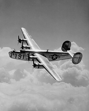
At 7pm on the evening of July 3, 1943, B-24 #42-7011 took off from Salinas Army Air Field on a night time navigation training mission over the Pacific Ocean. A few hours into the flight, the crew discovered the plane was using fuel at an excessive rate, and turned immediately for the coast. About an hour west of Point Conception, one engine quit. Pilot "Skip" Johnson told the crew to be ready at any time to bail out, but to wait for his order.

As they sighted the light beacons at Point Conception, a second engine quit, and the bomber went into a steep dive. Navigator Peter Dannhardt and bombardier Robert Prosser panicked and exited the plane through the front landing gear doors. Johnson and co-pilot George White were able to pull the plane out of the dive and limp to Santa Barbara on two engines. At 2am on July 4, Johnson gave the bailout order and then it was discovered that Dannhardt and Prosser were missing.

All eight crew members who bailed out over land survived. #42-7011 crashed in the mountains ten miles north of Santa Barbara. Several B-24's were sent out from Salinas to look for the two missing crew members. One of them was B-24 #42-7160.

In addition to its normal ten man crew were pilot Douglas Thornburg and navigator Justin Marshall. Thornburg was in command. On the foggy morning of July 5, 1943, they were flying an east-to-west zigzag pattern over the ocean between Santa Barbara and Point Concpetion.

Another bomber reported spotting a life raft near San Miguel Island, so the crew of #42-7160 decided to go in for a closer look. They were last seen headed west, descending below the fog layer at 500 feet. At about 8am they slammed into 800 foot tall Green Mountain on San Miguel Island at full speed.

Two parachutes washed up on a beach west of Santa Barbara, but Dannhardt and Prosser were never found, and were presumed drowned. The surviving crew of #42-7011 swore their fuel system and radios had been sabotaged,but the Army Air Force accident report concluded the pilot and flight engineer had not set the fuel mixture correctly on the bomber's engines.

The wreck of #42-7160 was discovered on San Miguel Island by a sheepherder named Robert Brooks on March 19,1944. The Navy removed the remains of the crew. In 1954, hikers on the island found additional human remains near the wreck and reported this to the Air Force.

A Coast Guard cutter was dispatched from Long Beach, and en route to the island, it struck the civilian sailboat Aloha, killing two passengers. After this final incident, the Navy began using San Miguel Island for bombing practice, and blew up 20(% ?) of the wreck of #42-7160. Pieces remain there to this day.

Thank you so much Elizabeth. I hope one day you can visit our display at the museum. I will print out this photo and get it framed. And the poem which was written for his parents and reads:

TRIBUTE TO DOUGLAS THORNBURG
Just feel proud, dear mother heart,
Your precious son, a glorious part
Has taken in this world wide fray
To free all lands from Axis sway;
The silver wings that bore him hence
While you each day endured suspense,
Flashed through the sky on duty bent
The job to do with full intent;
And though his ship may missing be,
Perhaps on land, perhaps on sea,
At conflict's end your gallant son
May come again when war is won;
But should there be a different story,
Just know he flashed his way to glory.
-Gertrude J. Hager
Written for Mr. And Mrs Hix Thornburg of Casa Grande whose son Douglas is reported missing.


Our hope is that we can complete the crew roster history and find the stories of the other crewmembers of tail number 42-7219. "Our own B24". To rest in obscurity is not an option, for me anyway.

Bruce Batchelder

Tuesday, June 9, 2009

The F6F ___Our First Ground Trip to the Site


First Try ___ Terry Weathers, Bill Lloyd, Jim Gubetta, Bruce Batchelder. June 8.

We ran up the South Fork of the Sacramento River on Road 26 to and through Mumbo Basin, intersecting Road 25 (these are county numbers, I think) at a gulch whose name I have already lost (there are a LOT of gulches up here). We then followed 25 generally west along the East Fork of Trinity River, looking for a north-bound spur that might lead into the target, Section 11.

After many stops to check our route (see map) we hit a road that led to the Altoona Mine which is just a section west from the Integral Mine which is just a section away from ours, number 11. The Altoona mined cinnabar, the ore that produces mercury and it has been leaching into Trinity Lake so the EPA's Superfund just finished burying all the mine tailings in a clay-lined pit and sealing it. I'll attach a picture.


Anyway, several backups, some don't-go-there skid paths later we hit 38N24 which led up the west side of section 11 and back to 26 at the top, and home. Enroute we found one of Jim Nile's old markers dated 6/5/57, I'll attach a photo. It says we were standing 1,610 chains east of the junction of sections 10,11, 15, & 14 (left to right, top to bottom).

So in short we did not find the plane but we did encircle the section where its remains were last seen and
we are reasonably certain that we can penetrate the area from the west, coming down 38N24 from county road 26. There looked to be at least two spur roads leading into the search area.


We think that the craft may have impacted in the north part of the section, along an east-west cruise line that Jim Nile performed in 1954 and that the Navy may have dragged the larger parts of the wreck to an open mine pit lower down the slope where Jim Gubetta saw it in 1957. This was close to the old county road where they probably trucked it out for salvage. Depending on how extensively the ground was disturbed with logging both sites should give up some evidence of the wreck.

Another trip is planned, more direct this time, to pinpoint both the pit and the higher impact point. If we can establish either we will advise the wider group that (or not) a formal survey may be in order. The tentative date for this second visit is Friday 19 June and we will again meet at the dam at Lake Siskyou, this time at 8am in order to give us enough time on site.

Please let me know if you are interested in this one. As you can see from the photos a 4WD vehicle with high clearance is helpful. The first tour was about 100 miles but this should be maybe half that as we have a much better idea of where to go. We also learned that cell phone signal strength is little to none so I'm hoping we can round up some walkie talkies, especially if we also have ATV's to work with. The terrain is steep but there are innumerable skid roads and ATV's could fan out and report back.

In the meantime Jim suggested finding out who logged that section since 1957 and Jason volunteered to check USFS records. Jim will also work with Jim Nile who is the other eyewitness (saw blue metal about 3/8 mile from the north edge of the section) because Nile may be able to help us locate who logged the area since the 1950's. We think it may have been done in the 70's or 80's and if we can locate any fallers who worked that slope we might obtain more exact location details.

Thursday, February 19, 2009

A Local Milestone, of sorts


For the first time since we began real estate here I saw a home listed for under $100,000 (above, on Cottontail Dr.). As you might suspect it needs work and is dated. It is also I think, an REO or real estate owned. That is, the bank owns it because the owner gave it back to them under duress.

There are a rising number of these it seems. As many Siskiyou County natives say, it takes months for some things to reach us up here. Like the foreclosure waves rippling through the bay area for example. This week we met with a Redding broker looking for help with the REO's and foreclosures here. He has so many, and spread so far out, that he doesn't have time to drive up and show or take pictures.

Prices per square foot are below $100 more commonly, too. It used to be that $100 per foot was the builder's cost and in olden times homes were selling at $125 or even $145, where the builder could make a decent profit. Of course older homes should be less per foot than brand new ones; they have wear and tear, often need updating, and lack modern amenities.

The home above is $63 per square foot and owned by Countrywide, one of the first casualties of the ARM loan collapse. The bank is trying to get back what they loaned the owner and it's possible they may have to take a loss on that loan if they can't move the home for the actual balance.

I'm not trying to alarm anyone however. We have all seen home values falling and in extreme cases, owners walking away from their places. Buyers do seem scarce and wary; what if I buy and prices go even lower? Some who have been in the business through previous cycles feel that we are not yet at the turning point where demand has risen close enough to supply for prices to stabilize. Maybe that will happen this year and the certainty about it all is that it WILL happen. Cycles by definition repeat themselves and the supply-demand balance will return sooner than later we feel. Our phones are ringing more lately it seems and we are hopeful.

Tuesday, January 27, 2009

Help Wanted: a tenor and a back-up band


I sing bass and have been (in another life) in several singing groups and quartets. The music I enjoy most is from the 50's and 60's, the street-corner doo-wop sometimes acapella four part harmony. Not barbershop, but what most call the golden oldies.

Is there anyone out there who'd like to form a group? I'm not thinking performance but just garage jam type music. If we get invited somewhere, fine but I'm into the fun of it, not the glory.

Anybody out there?

Tuesday, June 24, 2008

Paul Allen's Flying Heritage Collection in Seattle


There is a brand new museum at Paine Field in Everett, WA where the Boeing factory is and I got a chance to visit with my son-in-law last week (Sally just yawned and asked for the keys to the car and the credit card. She and our daughter had a sudden shopping urge come upon them).

The operative word in the name is "Flying" because unlike most warbird displays, they actually fly these airplanes every other weekend. I didn't get to see that part as we left mid-week but if you check www.flyingheritage.com you can explore the various flying dates.

The P-51 shown is one of 15 fully functional warbirds from the U.S., Britain, Russia, Japan, and Germany. Only one, the Focke Wulf Fw 190D-13 Dora, is not flown as it is the last of its kind and just too valuable, but they fly a rotating pair of the others every other weekend so if you're going up that way give them a call (877)342-3404) because it'd be well worth it to make your visit coincide with their flying dates and times.

Admission is twelve bucks (or ten if you get carded a senior as I mistakenly was)and many of the volunteers either are veterans themselves or knew one and are very well informed. Of course if you do go be sure to go to the opposite end of Paine Field and take in Boeing's 787 factory and their museum, too!

Friday, May 23, 2008

Boeing C-40 Restored from Wreckage


This was Boeing's first passenger "airliner". It carried two passengers in the cabin and the pilot rode in the open cockpit at top. This one crashed near Canyonville in the 1930's, killing the single passenger and injuring the pilot. The passenger was a diamond merchant on his way to market and the stones began turning up in rings and jewelry around the area for years afterward.

Which just goes to show you that every airplane has its story. Our local airplane wreckage group plans to build a small marker this Monday, May 26 to B-24E tail number 42-7119 which crashed here on June 11, 1943. The site is next to Interstate 5 near Truck Village and the event is scheduled for 10 am. The public is welcome and if you'd like directions call me, Bruce Batchelder, at 938-0385.

Thursday, April 17, 2008

And then a Crewman Came Knocking on our Door . . .


After our story got in the papers I got an intriguing call from a man in Yreka. His name is Verne Kendall and he told me the most amazing story:

In June of 1943 Verne and his parents were living in a trailer alongside Highway 99 where Summit Drive now dead ends. There are some homes there now and the Kendall barn is still standing on the site.

Anyway, they were awakened around 2:30am by the roar of airplane engines overhead. "The sound was deafening" Verne says, "it actually rattled our trailer home it was so loud." Running outside in their pajamas the family looked up and saw a huge bomber above them, heading north with very obvious engine trouble.

It disappeared into the night and then, moments later, they heard it coming back towards them and then the crash and explosion perhaps a mile to the north of their home.

Then, not long after going back in the house they heard a knock on the front door. Mr. Kendall opened it to see a man in an olive drab uniform who very politely asked him for a ride into town, saying he had just bailed out of the plane that crashed nearby.

Verne remembers his dad doing just that and seeing the burned crash remains the next morning from the highway. He also remembers finding 50 cal shells right in his yard, saying "they were jettisoning everything they could to keep altitude so there was stuff scattered all over the area."

While we're pretty sure now that part of the impact site now rests under the southbound lanes of Interstate 5 this last remark further supports our hope that local residents may possess such things. I again appeal to any reader(s) who think they might know someone with such an artifact to contact me, Bruce Batchelder, at 938-0385 to discuss loaning it to the museum.

The most remarkable part of the story of course is that Verne actually saw a survivor and is alive and able to tell about it. Verne and his wife run the Coca Cola Shop in the Bottling Works Mall in Yreka and happy to share the memory with others who are interested.

Tuesday, April 1, 2008

B-24 Story Continues


As we continue to follow the fate of the aircraft and crew, new developments keep coming in which add flavor to the tale.
For example the student pilot in the left seat who survived the crash also survived the war (and other training exercises). He died in San Diego in 2001. Born in 1918, he would have been 100 years old this year.

And here's an interesting kicker; the instructor pilot, Douglas Thornburg, who also bailed out and survived, was killed only 25 days later on a search and rescue mission around the Channel Islands west of Santa Barbara (can you belive it... looking for two crew who bailed out of ANOTHER B-24 that ditched!). Again, he had two student pilots running the ship but against orders it descended into the overcast and crashed on San Miguel Island. See the full story on www.california.rural.blogspot.com.

I continue to seek descendants of the crew as well as local witnesses who may have souvenirs of the crash to establish for certain that it was OUR B-24E, tail number 42-7119 (for example, the manufacturer was Consolidated in San Diego and they stamped "32" on most parts).

Please call me if you have any parts or stories about this aircraft. A great many local residents scoured the wreck for them and I would like to put together a museum exhibit of this incident with provable artifacts.
Editor

Thursday, March 20, 2008

B-24 stories are archived now

My daughter taught me how to "label" all the B-24 articles so that some one can keep up with the project and not miss new stories. Just look to the right under "Labels" and you'll see "local aviation (7)" and if you click on it the seven stories we have so far will come up.

This is number 8 actually; I'm calling for a dig and metal detector sweep of the site on Saturday April 5 for anyone interested in joining me. We'll meet here at my house (5225 Muskrat Rd.) at 9 am to plan because there are some things we can do wrong that will not only damage the site but desecrate a spot where six men lost their lives and we need to talk about some preventative steps we must take.

For example I will try to gather some wire flags, the kind they plant to mark buried irrigation lines so we can mark where artifacts were found. Then we'll need a grid to illustrate the finds, both on paper and on the ground. So I'll bring some stakes and string and flagging as well.

If you are interested and can bring either a camera or metal detector, please give me a call at 938-0385 and we'll get organized.

Bruce

Friday, March 7, 2008

Crash Debris is Military, at least


The items at right at first looked like hose clamps but thanks to Lloyd Foster at last night's EAA chapter dinner, we now know they are 50 cal. ammunition clips, the hardware used to hold machine gun rounds in long belt form. Thanks, Lloyd!

I am also advised by Craig Fuller (www.aviationarchaeology.com) who helped me find the tail number of this bomber, that any scraps of sheet aluminum containing the numerals "32" followed by a letter might also be attributable to a B-24 so on our next group dig we will be specifically looking for that.

Meanwhile the search continues for artifacts held by the public. According to stories the public salvaged quite a few pieces and residents called the Sherrif's Dept. for months afterward to report items found. If we can locate the owners of a few parts and persuade them to loan their finds to the museum we'll be able to mount a display. The same goes for photos. Wreck visitors may have shot pictures of it and those would be invaluable, too.

Are there any people out there with these things? Please call me at 938-0385 if you do or if you would like to participate in our next sweep of the site. If you have a metal detector that would be a big help.

Bruce Batchelder, Editor

Tuesday, March 4, 2008

B-24 Debris Recovered


Doyle Yandell was 8 years old when he stood on the shoulder of old Highway 99 looking down at the smoldering wreck of a bomber. It had crashed the night before and the whole town of Weed it seemed was there to check it out with him.

Doyle recalls seeing soldiers around the site (the Tunnel Guards from Company A of the 771st Division stationed at Camp Mott) and so he didn't go looking for souveniers. Then.

But yesterday he did. With me. And look what we found. Melted aluminum shards, rivets, hose clamps. And the thing is, they were all right at the toe of the fill where I-5 southbound lanes now are.

We scratched around the little hill but the shards were all on the front of it, not off to the sides. Of course there was too much snow to do a real sweep and we'd need metal detectors to do that. But an emerging pattern implies that eye 5 goes right on top of the main impact site.

A plane that size would of course create a large footprint upon impact. It apparently went in belly down with gear up so the impact pattern should be triangular in shape. But the darned hill is in the way.

All the newspaper stories say it came in about 350 yards (1,000 feet mol) west of where 99 crossed the SP tracks. When Doyle and I stood there, on the shoulder of I-5 looking down, it was hard to imagine the roadway being NOT there, and the glide slope leading right into that little hill.

I guess the point is that until and unless we can come up with some confirming artifacts (ordanance, parts with numbers on them, etc.) we just have a guess. Educated, but still a guess.

The reality is to have artifacts from the folks who "souveniered" the site. Apparently there were many. The news reports that people bombarded (excuse the pun) the Sheriff's Department with stories of recovered 50 caliber shells and other ammunition so it must have scattered quite aways around the original impact site.

The end game here is a display in the Weed Museum so if you have, or know someone who has, an artifact from this accident please call me. I want to button this thing down.

USFS photos are still pending as are blown-up copies of the wreck from the military microfilm archive so stay tuned. Doyle and I may be off a few yards and there may still be artifacts there when the snow melts and we can organize some metal detector owners willing to waste a few hours.

I'm hoping to sweet-talk Aaron Richardson into driving me there too, to confirm what Doyle and I saw today.

Is anyone out there?

Editor

Monday, March 3, 2008

The Tunnel Guards


During WW II, Company A of the 771st Military Police, Zone of the Interior, was stationed at Camp Mott, a now abandoned Forest Service campground located between Mott Airport Rd. and the interstate. Their job and that of other camps up and down the state, was to guard railroad bridges and tunnels against sabotage as trainloads of military supplies such as the one pictured at right, passed through our area.

I took the photo as Bob Marshall of McCloud held up his book, The Time-Life Pictorial History of WW II published just after the war, and it shows a train passing milepost 329 (the tiny white sign to the left of the train) which is just below Camp Mott. Thank you for sharing it with me, Bob. Note the guard riding on the flatcar. Bob, retired now 25 years and bearing down on his 90th birthday, has not lost a bit of his memory, either. He recalled for instance that the camp's water supply came from a spring just down from the tracks, about 150 yards south of where the old SP section crew quarters were (now where the road crosses near the old Diamond Lumber yard). He thinks the original hydraulic pump__a device to lift water uphill using the weight of the water as it runs downhill into a pipe__ is still located at the spring and that a trail may still be there leading to it. I'm going to try hiking in one weekend soon and will report what I find. Bob will probably out-hike me if I can talk him into coming along.

Dan Sebby from the California State Military Museum in Sacramento (916-442-2883), the man who provided the tail number for my lost B-24 on an aviation archaeology website, knew about the ZI (Zone of the Interior) MP's and suspected their function so Camp Mott and this photo corroborates his guess. He is interested too in our B-24 story so I'll forward this article to him as it was a group from this camp that secured the aircraft wreck site in the early hours of 11 June 1943. He would love to hear from any reader who might contribute to his military collection, too. You can email him at daniel.sebby@us.army.mil.

Finally, I learned that Ralph Brooks who owed our famous Windsor's Drug Store here in Mt. Shasta for years (remember their soda fountain?) with his wife Donna, was a Tunnel Guard during the war. If I can find him I'd love to get an interview. Maybe he was here!

That's all for now although photos of the B-24 are due this week and I'm getting closer to a site-sweep with metal detectors if anyone wants to come along.

Bruce Batchelder, Editor

Thursday, February 14, 2008

Bomber Mystery Solved !


Well, we were close. It was a bomber and it was WW II, June 10th of 1943 to be exact. But it was a B-24E in the 7th Bomb Group from AAF Salinas, CA. Pilot A.J. Thornburg and four additional crew were lost. I called for the full accident report and Missing Air Crew Report and will have more details when that arrives. I am also going to scour the microfilm at the library of the Siskiyou Daily News and the Mt. Shasta Herald for that date and subsequent weeks.

For those of you interested in this kind of research the key was the state military museum in Sacramento (916-442-2883) whose director, Dan Seddy pointed me toward http://aviationarchaeology.com (no "www.") where we drilled down through the AAIR database by country, state, and finally, town. Facinating site.

For fun I'm also checking Cal Trans because they filled the area when they constructed Interstate 5 and may have recorded any wreckage they found. I'm also chasing down the forest fire possibility through Cal Fire in Yreka. Finally, I'll try to take a photo of the oil pressure guage that Jim Kottinger has and include it with my next installment when the full accident report arrives.

Editor

Monday, February 11, 2008

The B-17 Mystery Grows


Bob Gray saw the wreck site from the air and Jim Kottinger saw it on the ground. He even has an oil pressure guage from the wreckage. So why can't we find a news story in the local papers? Dennis Freeman, the main man at the COS library searched all the paper archives for "bomber" and came up empty. If Dennis can't find it nobody can.

So did this crash happen or not? I've queried the National Archives, the Air Force Historical Society, the Mt. Shasta Herald, the Siskiyou Daily News, Smithsonian Air & Space Museum, the Sisson Museum, the State of Jefferson Historical Society, and of course the ultimate authority . . . . Google!

How can you have two eyewitnesses and no printed record? According to Bob Gray the aircraft went in just north of where old Highway 99 crossed the SP tracks. About where Skinners Truck Repair is now.

And even more intriguing, Jim Kottinger thinks the pilot knew about a small dirt air strip just off Deetz Road (covered over now by Plum Rd.) and just didn't have enough altitude to reach it.

Facinating stuff. Two crewmen died. And nobody wrote about it????

Does anybody out there know anything about this?

Editor

Thursday, February 7, 2008


B-17 Crash Near Truck Village in the 40's

My friend Will Bullington and I were chatting about the history of the old county airport north of Montague and how it was originally built to assist bombers in distress during WWII and he mentioned that his parents had told him about a B-17 that went down by Truck Village in Mt. Shasta during the war and started a forest fire, causing the area to be mostly brush to this day.

Intrigued, I went to the museum in Yreka but was unable to find any record of the incident. I have calls in to archival experts at both the USFS and CDF and will post comments to this story when I learn more but in the meantime is there anyone out there with any knowledge of this crash? Perhaps retired firefighters or residents of the Truck Village area? Or even parents and seniors who were in the area then?

Will said residents were calling the Sheriff's Department for some time afterward with recoverd parts of wreckage, even 50 caliber ammo so there may even be some artifacts here in our community in somebody's attic!

Please comment if you know anything.

Editor

Thursday, January 10, 2008


This is the county airport just north of Montague. It was apparently used as an emergency landing field during WWII when the Army Air Corps leased it and extended the runway to 7,300 feet to accommodate disabled B-17’s and other bombers. The military left in 1945 after the field was approved for scheduled commercial airline use (I’m still digging to see if any airline did land here; do any of you readers know?).

The field was re-commissioned during the Cuban Crisis in 1962, with interceptor squadrons from Hamilton Field and later Travis AFB based here under the “dispersal” strategy (I think this means scattering our forces so as to not lose all in one attack as happened at Pearl Harbor). By 1971 the field was again considered surplus and returned to the county.

Of interest is a 1998 report which appears to be an inspection for possible ordnance left by the military. A small depression was identified as an ammunition disposal area off the end of the abandoned NE-SW runway and several “hits” were reported on the team’s magnetometer. A farmer who had leased the land and filled in the small depression said the pit had been used for this purpose but he had filled it in to level his pasture.

At only one acre in size this “area B” is described as having possible ordnance by the report in the form of 20mm, bombs, and air-to-air missles. Recommended action is “EE/CA (RAC 4)”, whatever that means. I’m still digging.

In the meantime the field apparently is host to several private companies who lease space from the county, as well as Cowling Air, the FBO (530-459-0900). I’m told gliders use the runway as well and that many radio-control model flyers practice there in addition to some private pilots. I’ll go up one of these days and poke around to learn more. If I get some pictures I’ll post them along with any further news.

PS: If you or anyone you know were ever stationed or employed at this field, particularly as a military pilot we’d love to hear from you!
Editor

Welcome to the Lake Shastina Bulletin Board!

If you would like to submit an article about an event or topic of local interest, just click HERE. You can also post comments to share information or to offer tips at the end of each article.
Bruce Batchelder, Editor